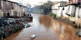
On the night of February 24, Nairobi experienced one of the heaviest rains in a very long time, with many residents being caught flat-footed. Many locations around the city were flooded, with the roads being rendered impassable and the people being stranded in buses and buildings.
The heavy rains continued for three weeks up to March 15. The downpour was higher than had been experienced in the past few years, with meteorologist Maithya wa Vilivu stating that some days even received up to 160mm of rain.
Many people were affected, including the garage owners at Grogan, whose properties were heavily damaged, and some of the vehicles were even swept away. They expressed concern, wondering how they’ll be able to recover the losses they had just faced.
Much of the blame for the floods was placed on the lack of a proper drainage system in the city, with emphasis on how we’re still reliant on systems built in decades gone by, with the intention of serving a million residents.
Rightfully so, the population has ballooned to five million residents over the years, but the systems serving the people haven’t been proportionately expanded.
The government has to find ways to solve the issue of land encroachment on riparian land, once and for all. Over the years, there have been a number of initiatives started to restore encroached land on the Nairobi River.
These initiatives did not fail as much as they didn’t succeed, and so, it is important to borrow lessons from them.
First, involve the riparian residents in the activities by providing solutions within their reach, and provide financial incentives for the collection of garbage in their vicinity.
Secondly, ensure that there is proper enforcement of existing legislation. This activity has been deeply poisoned by politics, barring the proper planning of the city, since politicians want to ‘protect’ for their own political benefit, yet when the residents suffer, they suffer alone.
Currently, there’s a multi-agency team that has been deployed by the national and county government to evict and demolish anyone who’s within the 50m riparian boundary. The traders in Gikomba were the first ones to be evicted, with their stalls being demolished on March 30.
It is important that we allocate this 50-metre buffer zone not to anything else, but dedicate it to greenery. That way, we’ll have enough permeable surface to allow stormwater percolation, hence there wouldn’t be a need to heavily rely on our drainage channels, and we’ll have controlled flooding in some of the regions.
This has succeeded in the historical Kamukunji public park, where the land next to the river was set aside as a playground, as well as the Community Park in Mathare, which has been restored from the terrible state it previously was.
Finally, why are new stalls being brought up next to the Nairobi River at the Globe Roundabout? Won’t they be affected the next time we experience floods?
Let’s not take two steps forward and five steps backward, and they included:
The Nairobi River Basin Rehabilitation and Restoration Programme (NRBP) of 1999 to 2008 The Ministry of Water & Irrigation’s 2016 Masterplan The Nairobi City Regeneration Programme (NCRP) of 2018 The Nairobi River Life Project (2021)
Benjamin Mulwa Langwe, a commissioner at the Nairobi River Commission recently stated that the marking of buildings for demolitions would begin soon, along the 27km length of the Nairobi River, so people should brace themselves. But that shouldn’t be done blindly. We should learn from the past.
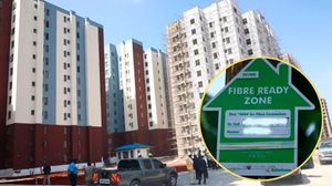
Additionally, the drainage problems have compounded over the years, with the loss of green spaces happening correspondingly to the increased concretisation of the city.
Sunday Abuje, in his research on the effects of climate change in Nairobi, explains that the rate of surface run-off has quadrupled in 20 years due to the 162 percent increase in the built-up area of Nairobi since 2002, particularly the high-rise infill developments in Upper Hill, Kileleshwa and Kilimani. There has also been a 50 percent increase in built-up areas along the Ngong River between 1976 and 2013.
Such developments reduce green space, increase the area of impermeable surfaces, and reduce stormwater percolation, thus increasing the run-off when it rains.
Therefore, when it rains, there aren’t enough surfaces to absorb the water into the earth, and so, it has to flow somewhere.
The overwhelmed drainage infrastructure constructed in the 70s, and the disappearance of wetlands within the city, collectively result in a 43 percent chance of flooding every time it rains.
We have seen areas that had been set aside to be detention ponds, such as the land where Parklands Baptist Church currently sits, as well as Nairobi Dam, being grabbed, yet this is where stormwater runoff should be held temporarily when it rains, before being slowly released through a controlled outlet in order to prevent downstream flooding.
The writer is Founder and Executive Director, Qwani
Unlock a world of exclusive content today!Unlock a world of exclusive content today!